A-level Geography Year 13 · Topic 5
Hazards
Hazards at A2 level brings together tectonic, storm and wildfire hazards, and how people perceive and manage them.
We will study hazard concepts, the disaster risk equation, and models like Park's curve and Degg's model.
Then we look in depth at plate tectonics, volcanic and seismic hazards, storms and wildfires, and multi hazard environments.
- 8 subtopics
- 250 questions
- Free: 5.1 notes and 6 questions
In this topic
- 5.1Tectonic hazards and managementFree below · 14 questions
- 5.2Storm and wildfire hazardsOpen in Full Marks · 8 questions
- 5.3Hazard concepts: hazard, risk, disaster, vulnerability and the disaster risk equationOpen in Full Marks · 27 questions
- 5.4Hazard perception and responses: Park's curve, Degg's model and the hazard management cycleOpen in Full Marks · 69 questions
- 5.5Plate tectonics theory: Earth structure, plate margins, hotspots and evidenceOpen in Full Marks · 41 questions
- 5.6Volcanic hazards: types, processes, impacts and secondary hazardsOpen in Full Marks · 26 questions
- 5.7Seismic hazards and tsunamis: causes, magnitude, impacts and secondary effectsOpen in Full Marks · 33 questions
- 5.8Multi-hazard environments: case study of interacting hazards and riskOpen in Full Marks · 32 questions
5.1 · Free notes
Tectonic hazards and management
Key points
- Plate movement is driven by convection currents, ridge push and slab pull; magma type and plate margin determine the style of volcanic activity.
- Seismic hazards: ground shaking, liquefaction, landslides and tsunamis. Magnitude is measured on the moment magnitude scale; intensity on the Mercalli scale.
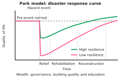
- The Park model (disaster response curve) shows the stages of relief, rehabilitation and reconstruction after an event.
- The hazard management cycle covers preparedness, response, recovery and mitigation.
- Vulnerability and resilience depend on wealth, governance, building quality, education and access to technology, which is why similar-magnitude events can have very different impacts.
- The pressure and release (PAR) model shows how root causes, dynamic pressures and unsafe conditions combine with a hazard to create disaster.
In more detail
- Turkey–Syria 2023: two earthquakes of magnitude 7.8 and 7.5 killed over 59 000 people; weak enforcement of building codes made the collapses far worse.
- Iceland, Grindavík 2023–24: the town was evacuated and earth barriers were built to steer lava away from the Svartsengi power plant.
- Earthquake engineering: cross-bracing, shear walls, base isolators and deep foundations help buildings survive shaking.
- Capacity to cope: New Zealand's national earthquake insurance scheme paid out for much of the damage in Christchurch.
- Land-use planning: California's Alquist–Priolo Act restricts building across active fault lines.
Practice
Tectonic hazards and management: 6 questions
Pick an answer to check it, or open the answer for the explanation.
1. What does the Park model show?
- Plate boundaries
- The stages of response and recovery after a disaster over time
- Volcanic explosivity
- Population density
Show answer
B: The stages of response and recovery after a disaster over time. It plots quality of life against time through relief, rehabilitation and reconstruction.
2. What is liquefaction?
- Lava flowing quickly
- Saturated soil losing strength during shaking and behaving like a liquid
- Melting of ice caps
- Sea water flooding land
Show answer
B: Saturated soil losing strength during shaking and behaving like a liquid. Buildings can sink or tilt as the ground loses strength.
3. Why do similar-magnitude earthquakes have very different impacts?
- Magnitude scales are unreliable
- Differences in vulnerability, building quality, governance and wealth
- Only depth matters
- Population is always equal
Show answer
B: Differences in vulnerability, building quality, governance and wealth. Development level strongly affects resilience.
4. What does the PAR model explain?
- Plate movement
- How root causes and unsafe conditions combine with a hazard to create disaster
- Volcanic eruption prediction
- Tsunami speed
Show answer
B: How root causes and unsafe conditions combine with a hazard to create disaster. It focuses on the human factors creating vulnerability.
5. Which stage of the hazard management cycle involves planning before an event?
- Response
- Recovery
- Preparedness
- Reconstruction
Show answer
C: Preparedness. Preparedness includes education, drills and early warning systems.
6. What does the Richter or moment magnitude scale measure?
- Damage caused
- The energy released by an earthquake
- Wind speed
- Rainfall intensity
Show answer
B: The energy released by an earthquake. The Mercalli scale measures intensity and observed effects instead.
Keep going in Full Marks
Full Marks has 14 questions on Tectonic hazards and management (8 more than here), set out in practice levels. You also get notes and 3D models for all 8 subtopics of Hazards, plus games, timed exams and past papers.
On your exam board
- AQATopic 1: Hazards
- OCR ATopic 3.5: Geographical debates: hazardous Earth
- CambridgeTopic 9: Hazardous environments
Not in the Edexcel specification.