GCSE Geography · Topic 10
Issue evaluation and UK geographical investigations
Issue evaluation and U K investigations are about applying everything you know to a real decision.
We will work through a pre release resource booklet, and make and justify a geographical decision.
Then we use geospatial data to investigate a U K issue, and practise writing top level extended answers.
- 4 subtopics
- 178 questions
- Free: 10.1 notes and 10 questions
In this topic
- 10.1Issue evaluation: working through an AQA Paper 3 pre-release resource bookletFree below · 33 questions
- 10.2Making and justifying a geographical decision: weighing evidence, stakeholders and sustainabilityOpen in Full Marks · 35 questions
- 10.3Edexcel UK challenges investigation: using geospatial data and secondary sources to study a UK issueOpen in Full Marks · 79 questions
- 10.4Extended-answer technique: 9-mark and 12-mark evaluative questions with SPaGOpen in Full Marks · 31 questions
10.1 · Free notes
Issue evaluation: working through an AQA Paper 3 pre-release resource booklet
Key points
- AQA Paper 3 (Geographical applications) lasts 1 hour 15 minutes and is worth 76 marks. Section A: Issue evaluation is worth 37 marks and Section B: Fieldwork is worth 39 marks.
- The pre-release resource booklet is issued about 12 weeks before the exam. You may research and annotate it beforehand, but you cannot take annotated copies in. A clean copy is given in the exam.
- The booklet is built around one geographical issue, such as a development, a management scheme or a conflict over land use. It always has a place, a scale and a choice between options.
- Resources include OS and location maps, photographs, graphs, tables, satellite images and text extracts with stakeholder opinions. Work out what each figure shows and what it cannot show.
- Before the exam, make a one-page summary: the issue, the places, the key figures with units, each stakeholder's view and the pros and cons of each option. Do not memorise a fixed answer, because the questions are new each year.
- The early questions test skills: grid references, scale (1:25,000 means 4 cm = 1 km), percentage change = (change ÷ original) × 100, mean, median, range, and describing graphs and anomalies. Always quote data with units.
- Stakeholders include residents, councils, businesses, conservation groups and national agencies. Check whether a source may show bias, for example a developer's promotional leaflet.
- Command words matter: describe (what), explain (why), assess/evaluate (weigh up and judge), and justify (give evidence for a choice). Match the depth of your answer to the marks available.
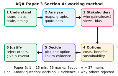
- The final 9-mark question asks you to make a justified decision between options. A top-level answer gives a clear decision, uses specific evidence from several resources, and weighs costs and benefits for different groups. It also explains why alternatives were rejected and ends with a conclusion.
- Add depth by linking to your course knowledge, such as sustainability, management strategies and named case studies. The decision must still rest on the booklet evidence.
- Timing: with 76 marks in 75 minutes, aim for about one minute per mark. Spend about 9–12 minutes on the final question, and plan with a quick table of option, evidence and who gains or loses.
- Show evaluation with phrases such as 'however', 'the most significant factor is' and 'this evidence is limited because'. Limitations include small samples, old data, one-sided sources and missing costs.
In more detail
- Worked preparation: list each figure in the booklet with one key fact, and learn its place names, figures and stakeholders.
- Worked command words: "assess" means weigh up importance; "justify" means give reasons for your choice, backed by evidence.
- Worked 9-mark plan: choose an option → reason 1 with evidence from the booklet → reason 2 → a counter-argument and why your choice still wins → a clear conclusion.
- Worked linking: if the issue is a new dam, link it to water security, displacement of people and sustainability from your course.
- Worked timing: 76 marks in 75 minutes is about a minute per mark.
Practice
Issue evaluation: working through an AQA Paper 3 pre-release resource booklet: 10 questions
Pick an answer to check it, or open the answer for the explanation.
1. How long is AQA GCSE Geography Paper 3 (Geographical applications)?
- 1 hour 15 minutes
- 1 hour 30 minutes
- 2 hours
- 1 hour
Show answer
A: 1 hour 15 minutes. Paper 3 lasts 1 hour 15 minutes and is worth 76 marks: Section A issue evaluation (37 marks) and Section B fieldwork (39 marks).
2. How many marks is Section A (issue evaluation) of AQA Paper 3 worth?
- 25
- 76
- 37
- 39
Show answer
C: 37. Section A is worth 37 marks. Section B (fieldwork) is worth 39 marks, making 76 in total.
3. Which statement about the AQA pre-release resource booklet is correct?
- Annotated copies may be taken into the exam
- A clean copy is given in the exam; annotated copies are not allowed
- It only ever covers a physical geography topic
- Its contents are only revealed in the exam room
Show answer
B: A clean copy is given in the exam; annotated copies are not allowed. The booklet is released in advance for preparation, but a fresh unannotated copy is supplied in the exam.
4. A booklet table shows visitors to a National Park rising from 40,000 (2010) to 52,000 (2020). What is the percentage increase?
- 30%
- 23%
- 12%
- 77%
Show answer
A: 30%. Change = 12,000. (12,000 ÷ 40,000) × 100 = 30%. Percentage change is always calculated against the original value.
5. Annual rainfall (mm) at four sites is 62, 48, 55 and 71. What is the mean?
- 58.5 mm
- 59 mm
- 71 mm
- 55 mm
Show answer
B: 59 mm. Total = 236 mm; 236 ÷ 4 = 59 mm. 58.5 mm is the median (the mean of 55 and 62).
6. Which sentence uses booklet evidence best?
- The graph shows the number of visitors.
- Many people visit the park.
- Figure 3 shows visitors rose by 12,000 (30%) from 2010 to 2020.
- Visitor numbers are going up a lot.
Show answer
C: Figure 3 shows visitors rose by 12,000 (30%) from 2010 to 2020.. It names the resource, quotes figures with units and gives the period. This precise use of data earns higher-level marks.
7. Which booklet source is most likely to be biased about a proposed quarry?
- A leaflet from the company wanting to open it
- A Met Office climate table
- An Ordnance Survey map extract
- A university geology survey
Show answer
A: A leaflet from the company wanting to open it. A company promoting its own scheme has a vested interest, so its leaflet may be one-sided. The other sources are independent.
8. What should a top-level answer to the final 9-mark decision question include?
- Only your personal opinion
- Only the advantages of the chosen option
- A chosen option backed by evidence, plus reasons for rejecting alternatives
- A list of everything in the booklet
Show answer
C: A chosen option backed by evidence, plus reasons for rejecting alternatives. The question rewards a clear decision, evidence from the resources, balanced consideration of other options and a justified conclusion.
9. Roughly how long should you spend on the final 9-mark Section A question?
- About 9–12 minutes
- 1–2 minutes
- 40 minutes
- About 25 minutes
Show answer
A: About 9–12 minutes. With 76 marks in 75 minutes, about a minute per mark is available. An extended decision answer needs a little extra time for planning.
10. On a 1:25,000 OS map in the booklet, 4 cm represents what real distance?
- 4 km
- 0.5 km
- 1 km
- 2 km
Show answer
C: 1 km. 4 cm × 25,000 = 100,000 cm = 1,000 m = 1 km.
Keep going in Full Marks
Full Marks has 33 questions on Issue evaluation: working through an AQA Paper 3 pre-release resource booklet (23 more than here), set out in practice levels. You also get notes and 3D models for all 4 subtopics of Issue evaluation and UK geographical investigations, plus games, timed exams and past papers.
On your exam board
- AQATopic 7: Issue evaluation, Topic 9: Geographical skills
- OCR ATopic 7: Geographical skills and fieldwork
- OCR BTopic 9: Fieldwork and geographical skills
- EdexcelTopic 8: Geographical investigations: UK challenges, Topic 9: Geographical skills
Not in the Cambridge specification.